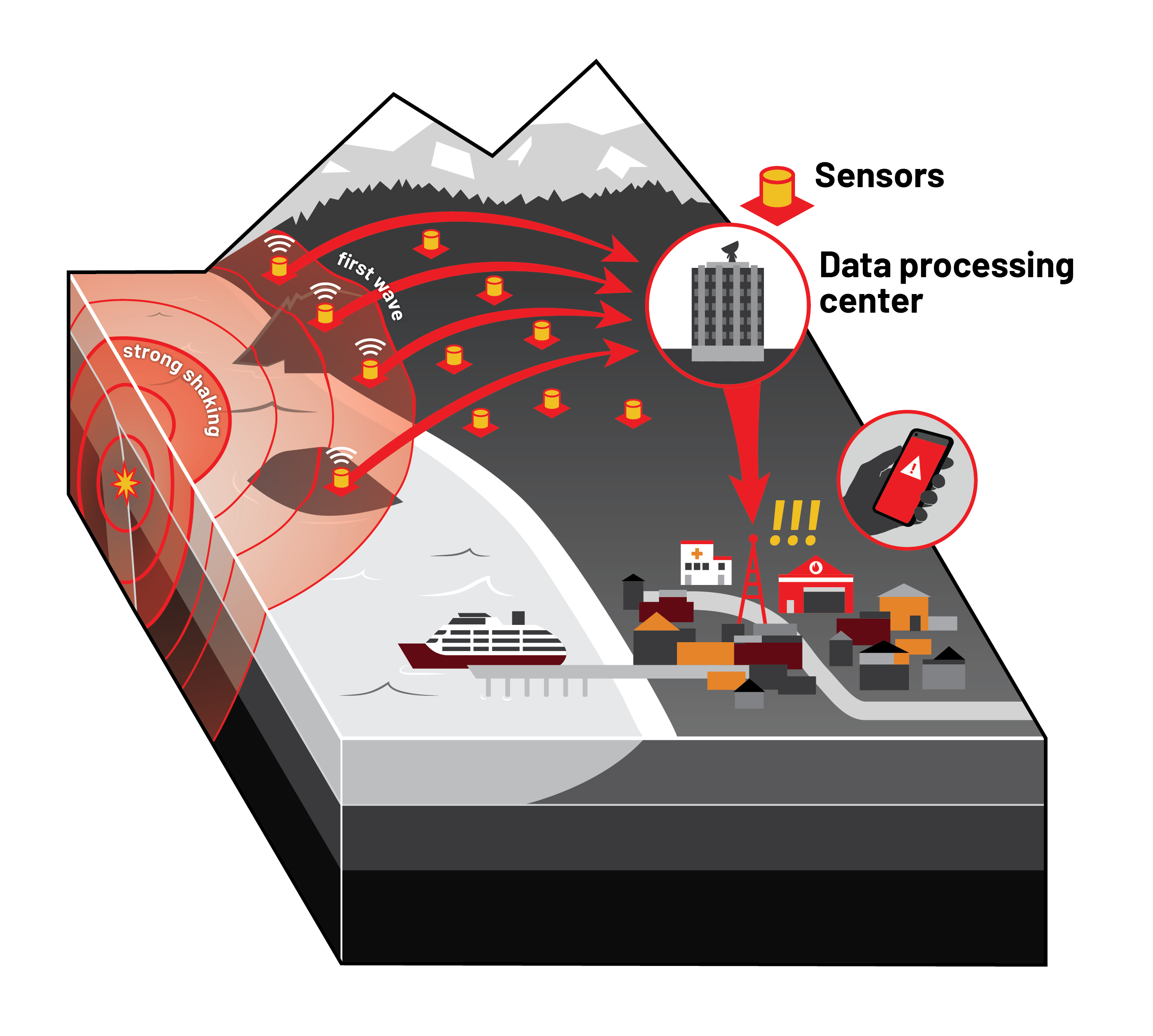
Earthquake Early Warning systems—in place in several countries and U.S. states—warn people before damaging earthquake waves reach them. Rather than predicting, the system relies on a seismic network to (1) detect early, non-destructive seismic waves, (2) rapidly estimate an earthquake location and magnitude, and (3) issue a widespread alert before strong shaking reaches areas away from the epicenter.
People should expect shorter warning times for stronger shaking, so it is important to take protective actions immediately after receiving an alert.
How it works
- An established seismic network rapidly detects incoming seismic waves after an earthquake.
- A data center determines location and magnitude.
- An alert is issued to a messaging system to warn people before the shaking reaches them.
- Some automatic actions may happen, such as shutting off gas lines or securing emergency response facilities.
- This all happens within seconds.

Where ShakeAlert® is in use already
ShakeAlert® is the national system for earthquake early warning led by the US Geological Survey in partnership with select states. The ShakeAlert® earthquake early warning system has been in use in California since 2019 and Oregon and Washington since 2021.
Natural Resources Canada worked with USGS to create a ShakeAlert® system that launched in 2024 in British Columbia. Quebec and Ontario are planned for 2025.
Implementing Earthquake Early Warning in Alaska
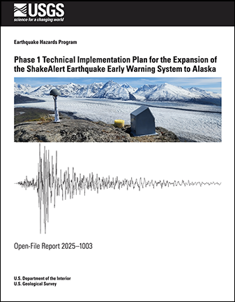
 The U.S. Geological Survey published Phase 1 Technical Implementation Plan for the Expansion of the ShakeAlert Earthquake Early Warning System to Alaska, in partnership with the Earthquake Center. https://doi.org/10.3133/ofr20251003. Below are some highlights from the report.
Phased Implementation
The ShakeAlert® rollout in Alaska is more ambitious than anything tackled in the lower 48 so far, with challenges including field logistics, telecommunications, diversity of earthquake types, and more. This will require development and testing. Phase I targets areas of the state that have the largest earthquake risk. The development and testing conducted during the Phase I rollout should enable eventual expansion to the entire state.
The USGS and partners could build out the ShakeAlert® system in Alaska incrementally, building on the foundation of the substantial existing federal and state government investment in sensor networks, data telemetry systems, data processing centers, and software for earthquake monitoring.
Phases:
- he initial focus would be on the highest risk region of Southcentral Alaska.
- Buildout would then proceed westward toward Kodiak, eastward to Prince William Sound, and northward to Fairbanks.
- The final stage would encompass buildout in Southeast Alaska.
- The phased rollout of general public alerting in one of these regions could begin as soon as the system is sufficiently built out, alerts can meet appropriate standards, mass alerting technologies are ready, and there are materials to educate the public adequately about how to respond to alerts.
How much will it cost?
$66 million: The estimated cost (2024 dollars) of completing the computing infrastructure and sensor networks for the Phase 1 ShakeAlert®expansion to Alaska.
$12 million per year: The estimated annual operation and maintenance cost (2024 dollars) once the early warning system is fully built out.
Funding Sources
ShakeAlert® is a state-federal partnership. State investment is essential for building public awareness campaigns. This investment makes it possible to coordinate multiple state entities including emergency managers, geologic surveys, and universities. It also allows the ShakeAlert® effort to adapt to the unique needs of the region. The USGS would work with the State of Alaska to determine an appropriate cost share for this investment. (Additional investments by third parties that may be needed to implement ShakeAlert® automated actions are not included in this cost estimate.)
How long will it take?
Initial year: project initiation, during which processes and contracts would be put in place.
First few years: The majority of the annual costs would go toward installing new stations, upgrading existing stations, and hardening communications.
Any timeframe for achieving operational status for ShakeAlert® in Alaska would depend on annual levels of both state and federal investment. The more quickly the annual funding required to cover costs is reached, the more quickly the system would become operational.
Equipment and Stations
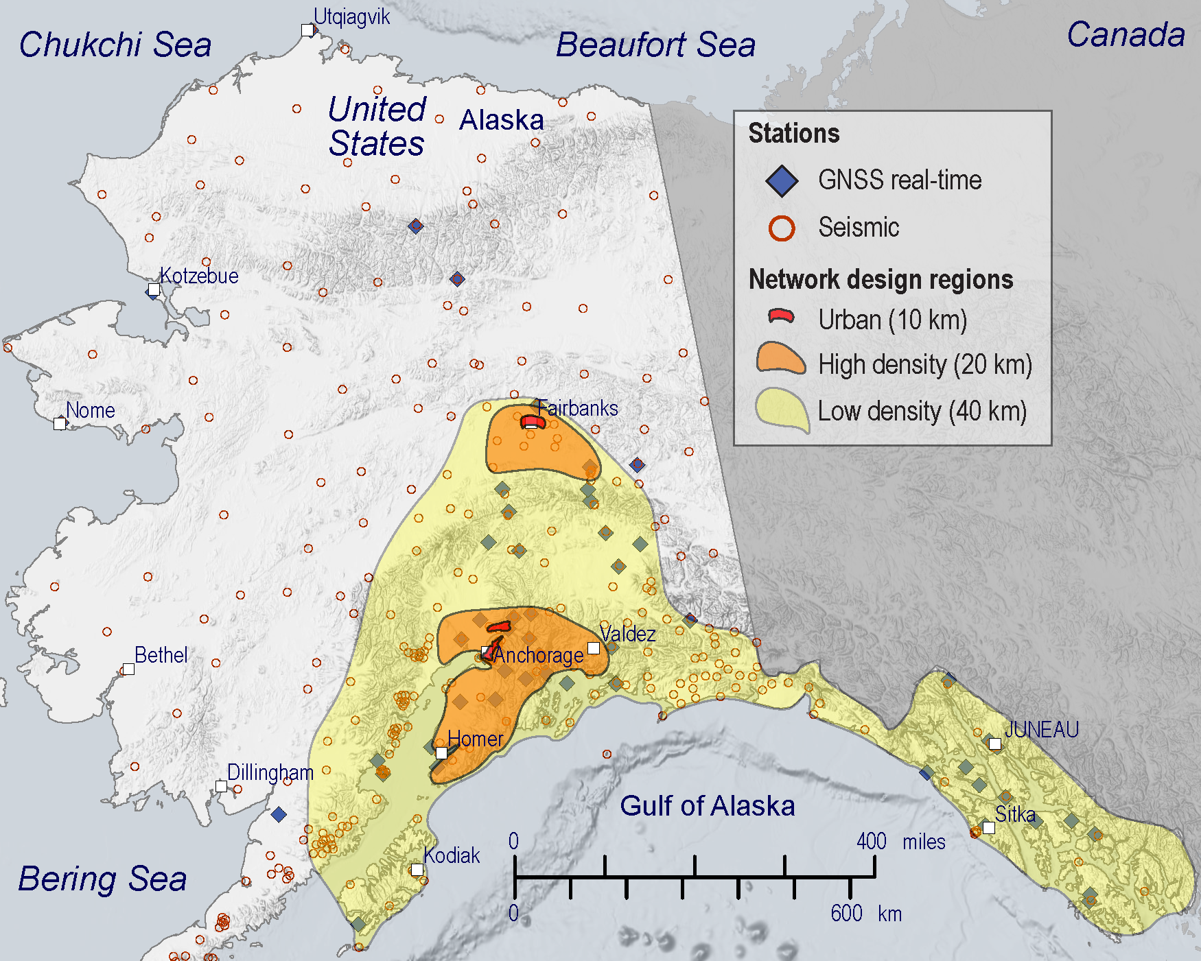
This plan calls for a total of 450 high-quality, real-time, early-warning-capable seismic stations in Alaska:
270 new stations,
160 upgraded stations, and
20 existing stations.
These seismic station numbers are based on a station spacing of 10 km in urban areas, 20 km in seismic source areas that endanger population centers, and 40 km in other areas.
Given the size of Alaska, the geographic distribution of population and infrastructure, and the characteristics of Alaska’s earthquake risk, a statewide system would not be well justified by a cost benefit analysis. Therefore, a geographically limited, Phase 1 goal was chosen that covers the highest risk and most populated areas of Alaska.

Low-Density Region (station spacing ~40 km). This area (yellow region in map above) has a sufficient level of coverage so that earthquakes occurring anywhere in this region can be detected and alerted by ShakeAlert®. The system also alerts on earthquakes that occur outside of this area but are close enough to generate strong ground motion in the ShakeAlert® region. That includes offshore earthquakes on the subduction zone, offshore earthquakes along Southeast Alaska, and large ruptures originating west of Kodiak Island. All of this region is considered a high seismic hazard. This region is capable of generating large earthquakes with the greatest potential to impact areas a few hundred kilometers away.
High-Density Region (station spacing ~20 km). Earthquakes occurring in these regions (orange regions in map above) are detected and alerted by ShakeAlert® more rapidly owing to the closer station spacing. This ShakeAlert® region meets all three of the following conditions:
1. high estimated seismic hazard
2. strong, shallow earthquakes generated inside the region (crustal or slab)
3. considerable urban, military, or private infrastructure
Urban ShakeAlert (station spacing ~10 km). Seismic station density is highest near the Anchorage and Fairbanks urban areas. Earthquakes offshore can be challenging for ShakeAlert® to locate precisely. The design also includes support for ten arrays (with location to be determined), which can provide accurate information to improve ShakeAlert® performance for offshore events.
Upgraded Stations along the Alaska Peninsula and Aleutian Islands. The plan also includes support to add twenty strong motion sensors to some existing seismic stations on the Alaska Peninsula and Aleutian Islands, in order to improve traditional earthquake monitoring for this region and to collect data that would help evaluate any possible future ShakeAlert® expansion.
The associated costs also include support for some early-warning-capable Global Navigation Satellite System (GNSS) stations (a more accurate version of GPS), with a focus on improving warnings for large subduction zone earthquakes.
For effective earthquake early warning, ShakeAlert® requires communications links that transmit data quickly and reliably in real time from field stations to the data centers.
The Alaska earthquake early warning plan includes two geographically separated data centers in Alaska.
Alert distribution
Earthquake early warning facilities will serve rapid, reliable alert products, including event messages, updates, status, and follow-up messages to technical users and the public. Although ShakeAlert® messages and follow-up messages are generated by the system, the USGS depends on the capabilities of other agencies and private sector partners to tailor and distribute these alerts and messages for the public and their clients.

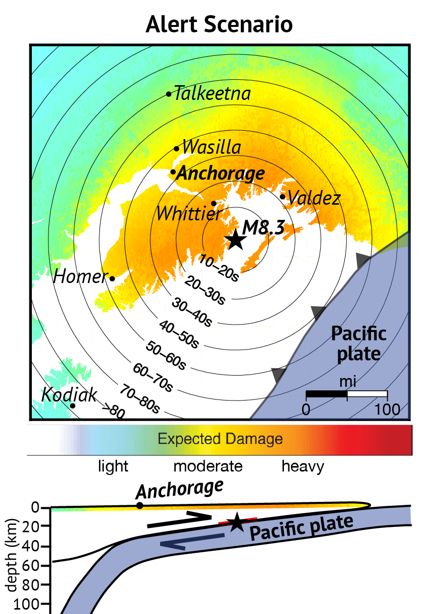
Bottom: Cross section showing the earthquake's location between the two plates (black star) and the size of the rupture (red line). An earthquake in this location would likely cause a tsunami.
The geographically limited, Phase 1 goal covers the highest risk and most populated areas of Alaska. The areas proposed encompass the main population centers and 90% of the state’s population. This Phase 1 design is considered very challenging and ambitious from the viewpoint of network operators. The lessons learned from implementing this plan could be used to consider subsequent phases to expand earthquake early warning beyond Phase 1 in Alaska in the future.
The Phase 1 rollout of public alerting in Alaska would begin when seismic network density in the region is built out sufficiently to ensure timely and reliable earthquake early warning. This is because stations must be close to faults that generate earthquakes in order to enable rapid alerts (especially when these faults are in urban areas).
How will earthquake early warning be related to tsunami warnings?
Because Alaskans already receive warnings for potential tsunamis, the rollout of ShakeAlert® will require strong coordination with NOAA.
Poorly targeted tsunami warnings have been an issue during recent earthquakes. ShakeAlert® geotargets recipients in a different way and–unlike the tsunami system– allows for alert dissemination by licensed private partners. If done correctly, the technical developments of ShakeAlert® should be able to improve the dissemination of tsunami warnings. Ideally, these will be rolled into a single coordinated message.
The expansion of the monitoring network that will enable ShakeAlert® includes the same instrumentation that is used for tsunami warning (seismic stations, GPS/GNSS). The ShakeAlert® network will directly improve the accuracy and timeliness of tsunami forecasts.
Because earthquakes and tsunamis in Alaska are part of a single natural hazard event, public education of these events is unified. In recent years NOAA has dramatically cut its support for Alaska’s in-community education programs under the NTHMP (National Tsunami Hazard Mitigation Program). The ShakeAlert® plan includes a significant public education component that would allow the Earthquake Center and other state partners to rekindle the strong tsunami/earthquake outreach programming that used to exist.
How will earthquake early warning benefit Alaskans (and visitors)?
Individuals
- Public alerts. Provide alerts via smartphone, siren, and public broadcasts before shaking starts locally.
- Personal action. Provide time to take personal action—duck under a sturdy table, move away from windows and hazardous materials.
- Preparedness. Alerts and drills build a culture of preparedness and reduce panic during actual earthquakes.
- Confidence. Early warning gives people a sense of control over their safety.
Industry
- Utilities. Automatically shut down gas and oil pipelines, reactors, and heavy machinery to prevent fires, leaks, and other damage.
- Workplace. Halt construction, stop factory operations, stop elevators to prevent injuries.
- Transportation. Stops trains, traffic, and runways to prevent vehicle crashes. Stop vehicles on bridges or in tunnels. Get out of landslide and avalanche zones.
- Minimize losses. Automatically close valves, lock precision machinery, and protect critical assets to avoid equipment damage or employee injuries.
- Economic growth. Demonstrate that Alaska has the same proactive earthquake measures as other states and countries.
Emergency Preparedness
- Hospitals. Move patients away from hazards and secure patients in surgery to prevent injury to vulnerable people.
- Schools. Guide students through preventative actions.
- Emergency responders. Prepare first responders and their facilities (for example, automatically opening garage doors to ensure vehicles do not get stuck inside).
Military
- Intelligence. Provide advance notice of potentially compromising situations for military bases and installations.
- Prepare. Take individual actions for personnel safety. Halt dangerous or sensitive operations, and secure munitions so shaking does not cause damage.
- Readiness. Prepare hangers, vehicles, and response teams for quick mobilization in response to damage or rescue operations.
Science and engineering
- Data. Provide far better earthquake observations to improve understanding of future earthquakes.
- Tsunami. Improve tsunami warning accuracy using new early-warning-enabled data.
- Landslide. Advance landslide monitoring with expanded seismic network.
- Volcano. Improve the early detection of eruptions using the expanded seismic network.
- Resilience. Encourage earthquake-resilient construction practices with improved earthquake awareness.
Non-ShakeAlert® early warning
Google announced in September 2024 that its Android phones will soon receive earthquake alerts in the U.S., including Alaska. The Alaska Earthquake Center welcomed Google’s innovative approach and speedy delivery of an earthquake alert mechanism, as it supports our mission to strengthen Alaska’s resilience to earthquakes and tsunamis. There are limitations to the Google system, however.
In the Google model, an Android phone with a built-in accelerometer serves as an earthquake detector. Enough phones near the epicenter would generate the information needed to alert those more distant to the impending shaking. Just like with any type of early warning that exists today, people close to the epicenter would have little to no warning.
This is not an “integrated” system – in other words, alerts only reach individuals who have Android phones with location sharing enabled. It doesn’t integrate with any type of emergency response action by an organization (e.g., gas valve shutoffs, emergency responders)
Because it only reaches phones, it cannot generate alerts for offshore earthquakes, which are common and destructive in Alaska.
It is a good start in AK, and people seem eager for any type of warning/alert. This is not a substitute for ShakeAlert®, which Google acknowledges (https://crisisresponse.google/android-alerts)
Learn More
Google Expands Earthquake Alert Coverage in U.S.
Alaska Earthquake Center article (September 2024) about Google's announcement that Android phones will receive earthquake alerts in the U.S., including Alaska.
How to Make Earthquake Early Warning Work in Alaska
Alaska Earthquake Center article (October 2023) about what early warning is and our initial assessment of what would be needed to make it work in Alaska.
“Get Ready Alaska” podcast interviewing the Earthquake Center’s Natalia Ruppert about earthquake early warning.
U.S. Geological Survey early warning information
Introductory information about what early warning is and where it is active. Sign up for ShakeAlert® earthquake alerts, news, and updates.
ShakeAlert®
Resources for emergency managers, educators, and outreach coordinators. These include videos and classroom activities, outreach toolkits, ShakeAlert® system information, and published research articles.
ShakeAlert® images and animations from IRIS
Education and training materials about how earthquake early warning works and what kind of warning times are possible, focused on California, Oregon, and Washington.


