
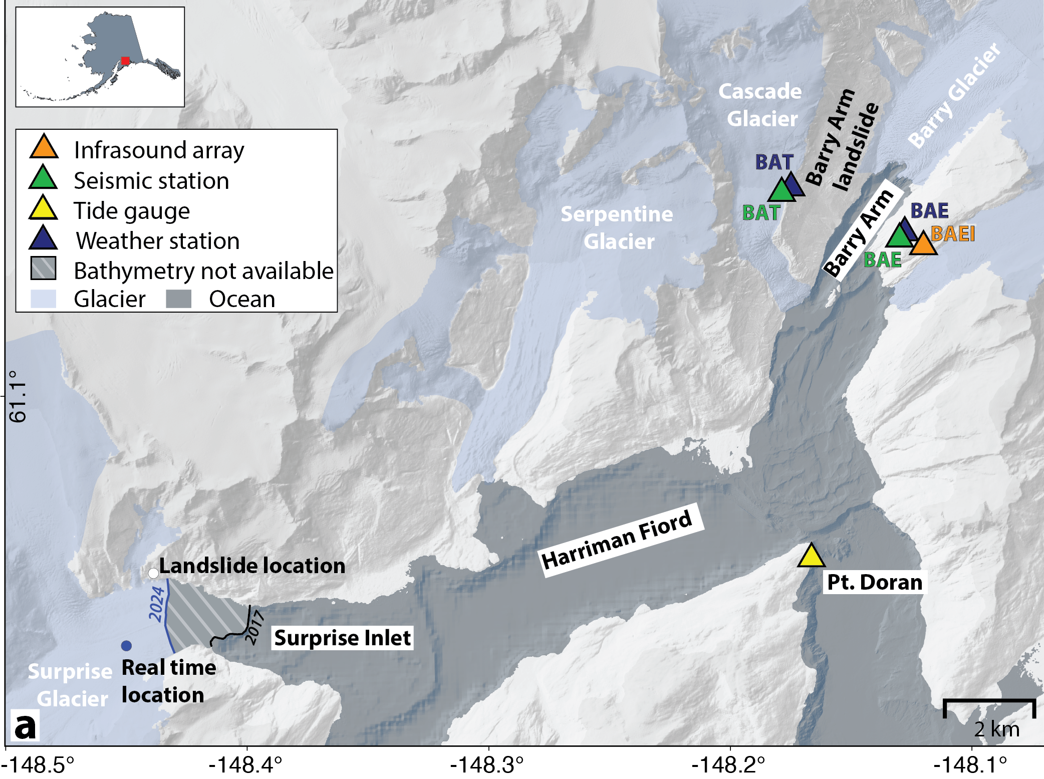


The Alaska Earthquake Center has been using seismic instruments to monitor unstable slopes in Prince William Sound since August 2023 (Figure 1). “We’re in the early stages of figuring out how to minimize exposure to landslide and tsunami risk,” says Earthquake Center director Michael West. “We’re earthquake people, and this is new to us.”
The effort is supported by several agency partnerships and grants. As landslides seem to become more numerous and destructive in recent years, scientists from multiple disciplines and agencies—from the U.S. Geological Survey, Alaska Division of Geological and Geophysical Surveys, and the Alaska Earthquake Center—have joined forces to understand where and when landslides occur, and what are the triggering mechanisms.
The multi-agency focus on Barry Arm is a byproduct of the experimental nature of the setup, which could prove vital in many landslide-prone regions of the U.S. “This is the best-studied site of a phenomenon we know is happening everywhere,” says West. The test area is set to expand this summer, to include most of Southern Alaska and most of our seismic network.
The research seismologist focused almost exclusively on fitting the seismologic piece into this multi-part effort is Ezgi Karasözen. She devised the computer-based approach that sweeps Prince William Sound seismic data every 30 seconds for signals unique to landslides.
The algorithm scans three-minute chunks of data from several dozen stations in the area. “Ideally, in 3-4 minutes we would know that a landslide has started,” says Karasözen. This is critical timing for southern Alaska’s steep coastal slopes, whose catastrophic collapse could trigger a tsunami.
Just such a failure in Greenland gained worldwide attention last summer, when scientists reported on a ~650-foot (200-meter) high tsunami triggered by collapse of a fjord wall. The tsunami decayed into a standing wave that was trapped in the fjord for nine days and caused a global seismic signal.
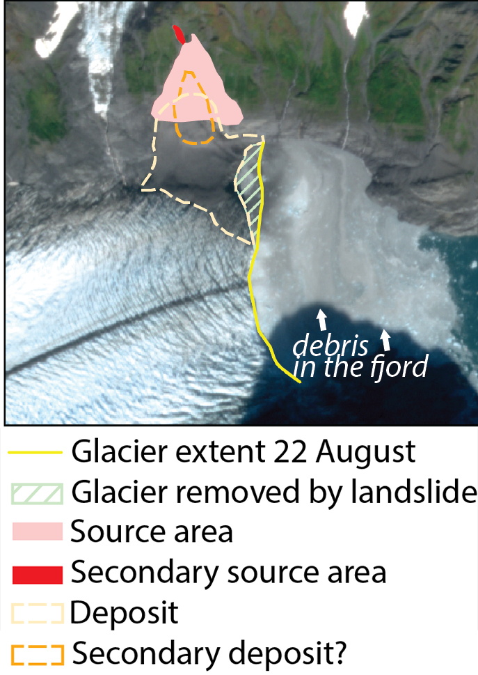
Since monitoring began, 28 landslides in Alaska were caught in real time. Last summer, two events—Pedersen Bay and Surprise Glacier—generated tsunamis, albeit small ones. Karasözen and West recently published their insights into the monitoring success of the Surprise Inlet series (Figure 2), which was picked up by seismometers as three separate landslides that were later verified by satellite imagery, tidal records, and infrasound (Figure 3).
This landslide monitoring program is offering a new window into slope activity in Prince William Sound, detecting landslides in near real time in a region where such events have often gone unnoticed.
The term “landslide” may call to mind scenes of a giant lobe of soil crashing downslope, engulfing everything in its path, but landslide is actually a blanket term for any parcel of rapidly moving land. It’s one of many types of soil, rock, or debris movement known in scientific parlance as “mass movement,” which can range from instantaneous rockfall to millenia-long creep of gently sloping ground.
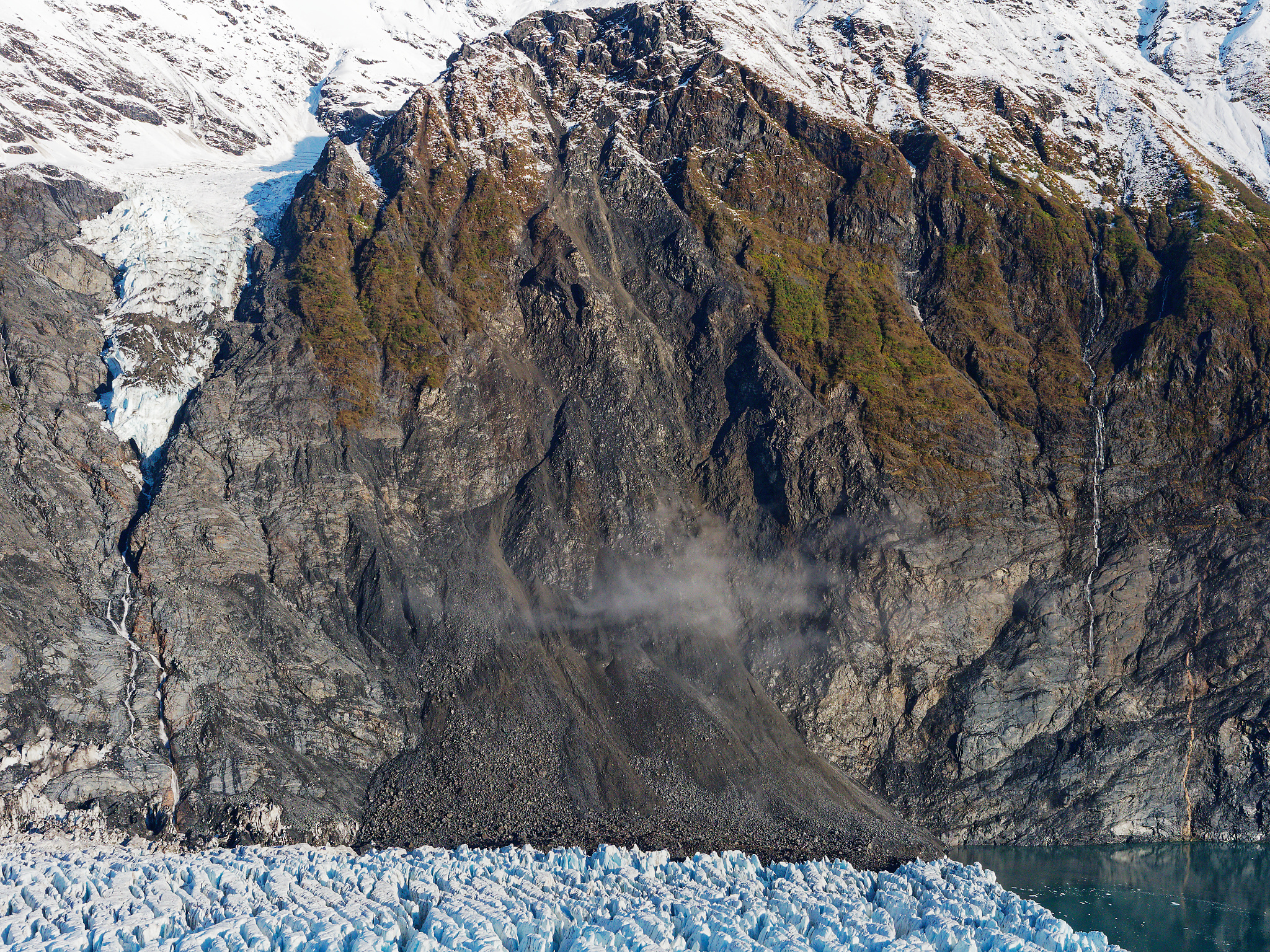
The mass movements that can be monitored seismically lie closer to the rockfall category, in that large volumes of rock that slide downslope create a robust seismic signal distinct from earthquakes.
“In Prince William Sound, we’re talking mountains made of rotten, old rock that can let loose,” says West. “These gigantic, unstable mountainsides have a history of collapsing, but this phenomenon does seem to be increasing in frequency,” he adds.
With about half of the two dozen landslides over the past year in this part of Alaska happening in August and September, West says, “We informally call this landslide season.”
Increased late-summer rainfall fills the pore spaces of soils warmed for months by the midnight sun, destabilizing slopes and increasing their risk of failure. Understanding what role weather plays in landslides is still an open question. “It takes multiple disciplines to understand where and when landslides occur, and what are the triggering mechanisms,” says Mort Larsen, a geologist and, until recently, manager of the landslide hazards program with the Alaska Division of Geological and Geophysical Surveys (DGGS).
Despite the gains made in Prince William Sound, not all landslides in Alaska can be rapidly detected with this method. Mudslides, for example, which are more common in Southeast Alaska, tend to be small, shallow, and quick, happening in saturated soil rather than crumbling bedrock. These movements wreak havoc on roads and homes, but their seismic signals are high-frequency and last just a few seconds.
“It’s not that the signals aren’t there,” explains Karasözen. “It’s just that they dissipate quickly and don’t reach the next station.” Only large, deep-seated collapses—like those in glacial fjords—create the type of long-period seismic waves detectable over a broader area.
The Earthquake Center’s test area has been relatively focused in an ~140-mile (~220 kilometer radius surrounding Barry Arm. “Right now we’re monitoring what we know is an active region,” Karasözen says. “If a slide happens there, we can detect it in real time, confirm it with other agencies, and contribute information to tsunami models.”
It takes just 20 seconds to process a detection once it's triggered. In areas like Barry Arm—where unstable slopes loom over deep fjords—every minute counts.
“The ultimate goal here is to be able to protect and save lives, if we can,” says Larsen.
When large landslides enter water, they can generate tsunamis, and the 2024 Surprise Inlet tsunami is a low-stakes example. In simulations of a worst-case Barry Arm collapse, a 6.5-foot (2-meter) high wave could reach the nearby coastal town of Whittier in just 20 minutes. Cruise ships and other ocean vessels, and the docks and piles that support them, all coexist in a narrow inlet that would trap and amplify tsunami waves.
“We’re still working on putting together all the pieces of information, from infrasound, radar, seismic, and tide gauges,” says Karasözen. “But now we’re in the position to detect a landslide and notify partners before confirmation comes in from these other tools.”
The seismic detection of landslide onset marks a turning point. “We’ve seen the culture change,” says West. “Now we can contribute to the broader hazard picture.”
Knowing that landslide activity kicks up in the summer suggests that climate change may stretch the hazard season, or make it harder to predict. The result may be a future in which landslides become more common, and more catastrophic.
Expanding the detection system across the vastness of Alaska is a challenge. While the Earthquake Center can tap into a 500-instrument-strong seismic network, in some parts of the state instruments are spaced by as much as 100 miles (160 kilometers).
“We need to design a detection strategy that leverages Alaska’s existing seismic network to expand our search on areas most at risk for landslides,” says Karasözen. She points out that the search has to be quick, and monitoring the whole state would take too long with current tools. “Should we come up with multiple grid search areas, or one giant one?” Karasözen remarks about next steps under consideration.
Larsen, who recently moved from the DGGS landslide hazards program to conduct landslide investigations for the Montana Department of Transportation, points out that the collaborative nature of the effort is crucial in Alaska. “We know Alaska has sparse data on where landslides happen,” he says. Multi-agency partnerships help to build an inventory of where they occur, and if there are patterns in place and time. “If we see lots of activity in one fjord, we can mark that it’s an active area and get the right people in the room talking about the next steps working forward. Does it merit a monitoring or early warning system?”
For now, real-time seismic monitoring offers some clarity in the hazy picture of Alaska’s landslide risk. “We’re not there yet with early warning,” says Karasözen. “But we’re building the tools that might get us there.”
New detection method aims to warn of landslide tsunamis